Bucknell Launches New Interactive Map Platform
July 14, 2025
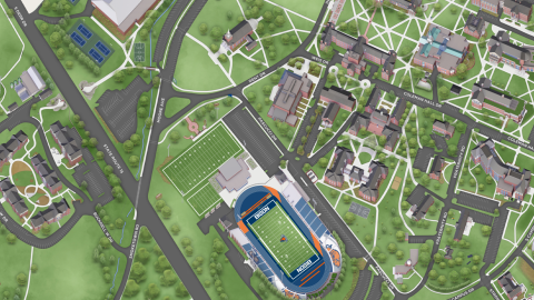
After a yearlong, collaborative effort led by Bucknell's Division of Marketing & Communications, Bucknell has launched the Concept3D platform — an interactive map that presents highly detailed, 3D renderings of buildings and grounds across the University's 450-acre campus.
"It’s not possible to see every corner of campus on your first visit," says Brandy Kift, assistant vice president, marketing strategy. "Concept3D makes it easy for anyone to explore campus more deeply from anywhere."
Utilizing a robust series of detailed layers, users can view maps that prioritize locations based on 13 unique categories, which include everything from academic buildings and outdoor spaces to campus housing and arts and entertainment. The interactive campus map, which was developed in partnership with Admissions, Facilities and Public Safety, highlights building names, safety features — such as AED locations — parking areas, dining options and other categories to help students, alumni, faculty, staff and visitors explore campus.
Within the map, users can select locations to learn additional information about facilities and, with more than two dozen 360-degree panoramas, users can feel like they've been transported right into the heart of buildings and campus landmarks, such as the Elaine Langone Center and Malesardi Quadrangle.
Users can print generated maps by accessing the print icon in the upper right corner of the screen. This feature gives users the opportunity to view and crop specific locations by panning and zooming the map and then print images with varying levels of details, such as a compass rose, 3D renderings and a base map that shows areas off campus. With turn-by-turn walking directions, users can more easily understand their route and reach their destination. Concept3D is compatible on mobile devices and desktops and uses alt-text that can be read from a screen reader, ensuring accessibility for visually impaired users.
The Concept3D platform serves as a powerful wayfinding tool that allows users to more easily visualize and navigate campus based on their personal needs and interests. This feature can be especially useful for campus events, such as New Student Move-in, Homecoming, Commencement and Reunion, where custom layers can organize and highlight information about recommended parking areas, shuttle stops and rain locations. "The platform offers a higher level of customization to provide a better user experience for multiple audiences," says Kift.
The customizable nature of the Concept3D map, which complements the Concept3D tour that was released in January, allows for additional levels of personalization in the future. "There's the possibility of creating separate tours that cater to different needs," says Kift, such as tours and maps that prioritize accessibility by spotlighting accessible routes and building entrances. "What we like about this tool is that it provides so much room for flexibility and growth."


